Day 7: Ridge Camp to Barrel Springs – 15.1 miles
Dan and I woke up to an incredible view. Stepping out of the tent we were greeted with a sunrise glow over the Valle de San Felipe and the Volcan Mountains. We’d only had the vaguest idea of our campsite because we’d hiked and set up our camp in the dark the evening before.

We had just gotten started on the trail when I noticed something shiny in the bushes. It caught Dan’s eye too and he decided to investigate. It turned out to be a large gold mylar balloon in the shape of a zero which still had some helium in it. Mylar balloons are made from metalycized polyester which makes them incredibly non-biodegradable. Unfortunately many celebratory groups still insist on using them as decoration and some inevitably get free or are purposefully released.
Thankfully they’re very lightweight as far as trail trash goes. However instead of popping the balloon and tucking it away, Dan decided to attach it to his pack. Of course he insisted that it made his pack lighter.

For the first five miles of our day we continued hiking gently uphill. There wasn’t much in the way of vegetation and certainly very little shade. The trail stayed on the west flank of the hills, giving us some pretty great views of the San Felipe Valley and the Volcan Mountains.
We knew we’d reached our five mile marker when the landscape suddenly turned to green. We stepped through a pipe gate and were surrounded by a small manzanita forest of. Shade!
I’d heard that there might be a water cache at this junction. It seemed pretty clear by the big sign stating “Water” pointing down a side trail. Dan let me get off my sore feet for a bit and moseyed the half-mile downhill to the cache. There he found hundreds of gallon-sized water jugs tucked under tarps. Meanwhile I found a log book in a metal case beneath the sign. I learned that the cache is maintained by local volunteers who’ve been providing water to PCT hikers for decades. I wrote out our thank yous and signed our names. Now we didn’t have to worry about rationing our water for another ten miles.


Our next five miles continued the uphill trend. We left the barren high desert hillsides behind and wound our way through chaparral-covered slopes. For those interested, the chaparral in this area consisted of scrub oak, ceanothus, chia sage, and sugarbush.
We knew when we reached the highest point because there was a rather unique landmark. On the map it’s called the Billy Goat’s cave. It was maybe a couple yards deep and a couple feet high – the perfect size for a single thru-hiker! It even looked like someone had slept there recently.


The trail topped out at about 4,400 feet elevation and crossed to the east side of the hills. As we rounded the peak, we had our first view east of Montezuma Valley and the San Ysidro Mountains. We were also met by a cold north wind.
It was pretty exposed so high up on the hill but both Dan and I really needed a break. We continued downhill for a quarter mile and finally stopped in a small patch of sunshine near the mouth of a canyon. It was really surprising how quickly the weather changed from one side of the hills to the other.


Our last five miles of the day were all downhill. The trail wound in and around the landscape as we descended the north-eastern slopes of the San Felipe Hills. I was moving slow, listening to a podcast and enjoying the scenery to the north when I came around a corner to find Dan stopped and pointing to the ground. We had reached the 100-mile mark on the Pacific Crest Trail as was indicated by a small rock formation. Of course we stopped to commemorate the occasion!

The last mile to camp was definitely the longest of the day. We’d been descending into a canyon so our views were gone. We passed through a handful of pipe gates marking the BLM lands boundaries and finally stumbled into an area of grasses and tall trees. It was really nice to see tall trees again.
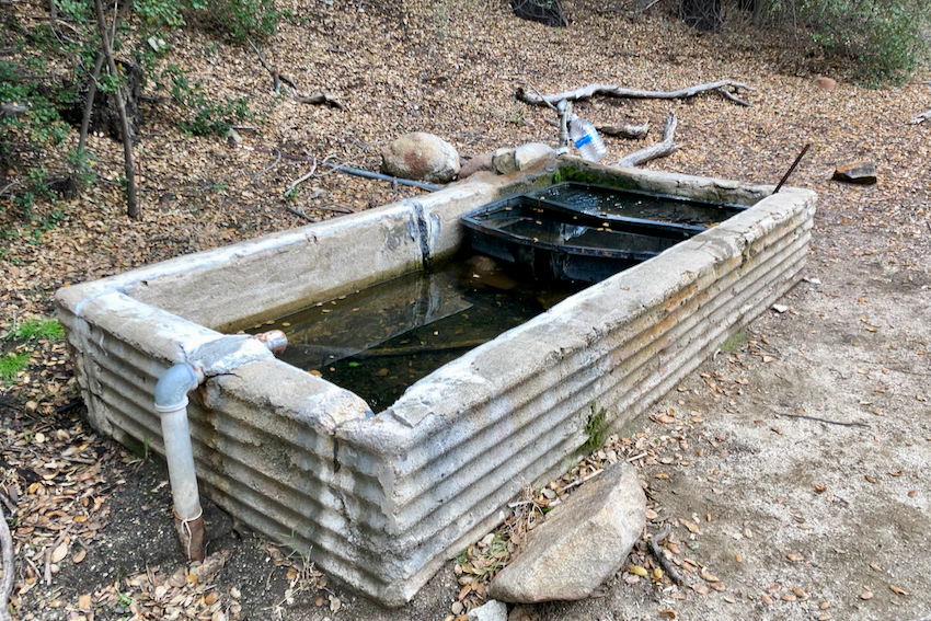
Our camp for the night wasn’t just a small tent-sized site but a legitimate trail camp known as Barrel Springs. This was also our one and only natural water source for our section hike. Sadly it wasn’t a pretty hillside spring like I’d encountered in Washington. Instead the water was piped into a cement trough which was certainly convenient but far from natural.

The camp was tucked into a small canyon and the sun was quickly disappearing from view as we set up our tent and made dinner. The air was warm in the canyon so we stayed up a bit after dinner to talk about our day and to finally enjoy one of the desserts we’d packed along.
Our section hike was nearly over. We only had eight easy miles left to reach the small town of Warner Springs where we’d be met by some friends from San Diego. I was feeling a bit wistful, wishing I could continue hiking but knowing that winter was about to set in. Plus, I really needed a shower.
1 comment
I’d like to use your picture of the Barrel Springs water trough as one of my fb cover pictures. Preparing for the PCT this April. I don’t have a website or blog started. Do I have your permission? Thanks.